The Degrees of Freedom for Signal (DFS) indicator
The impact of altimeter observations on mapping systems is traditionally assessed through Observing System Experiments (OSEs). An alternative diagnostic, the Degrees of Freedom for Signal (DFS), has been widely used in atmospheric and ocean modeling to quantify the effective observational constraint.
Within the former DT2021 CMEMS Level 4 (L4) processing chain, based on Optimal Interpolation, DFS could be directly derived from the error covariance matrix of the mapping system. This metric depends on the prescribed error budget (instrumental noise and correlated errors), which modulates the relative contribution of each mission in multi-altimeter configurations.
With the transition to the multi-scale MIOST mapping approach in November 2024, DFS computation is no longer available. Consequently, the relative impact of individual missions is now evaluated through dedicated OSEs. Specific experiments were conducted to quantify the contribution of each mission. The reference configuration includes all available altimeters (over the year 2024), while sensitivity experiments are performed by removing one mission at a time to assess its individual impact.
The computation of the relative contribution of one mission is done as :

These experiments assess the contribution of the altimeter missions available from 20240101 to 20241231 (Sentinel-6A, Sentinel-3A/B, Jason-3, Haiyang-2B, CryoSat-2, and AltiKa), using SWOT KaRIn observations as a reference (independent assessment of the mapping errors). Results indicate that Sentinel missions dominate the observing system across most ocean regions. In particular:
- Sentinel-3A/B contribute up to ~15% in high-variability regions,
- They also provide a substantial contribution in low-variability, equatorial, and coastal areas,
- Their impact in polar regions remains to be further assessed (not shown).
An example of the reduction of mapping error due to Sentinel mission is illustrated in Figure 1.
Figure 2 summarizes the contribution of the recent altimeter missions in the MIOST mapping system and in various oceanic regime (see figure 3 for the definition various regimes)
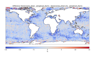
Figure 1: Example of error reduction in the mapping (expressed in %) for Sentinel-3A
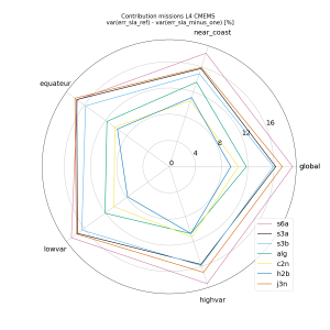
Figure 2: Relative contribution of the different oceanic regimes for each mission currently in operation.
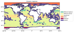
Figure 3: Oceanic regime defined for estimations of the contribution of the altimeter missions