Skip to content
Duacs
Altimetry data for sea level studies & applications
Menu
Home
History and Context
Mesoscale
Climate
Régional and L4P product
System
Acquisition and data selection
L2 Upstream data
Homogenization and cross-calibration
Along-track (L3) products generation
Merged gridded (L4) products generation
Final quality control
System version changes
DUACS NRT system impacting version changes
Apr 2022: DUACS 19.1.0
May 2022: DUACS 19.2.0
November 2022 – DUACS-NG 1.0.0
November 2023 – DUACS-NG 2.0.0
July 2024: DUACS-NG 3.0.0
November 2024: DUACS-NG v4.0.0
June 2025 : DUACS-NG v4.1.0
November 2025: DUACS-NG v4.2.0
DUACS MY system impacting version changes
January 2023: MY DT-2021 temporal extension
May 2024: MY DT-2021 interim temporal extension
Nov 2024: MY DUACS DT-2024 full reprocessing
Nov 2025: Demontrative L4 reprocessed series with new MIOST version
DUACS Products
Copernicus Marine Service products
Copernicus Climate Service products
Ocean Monitoring Indicators
Demonstration and pre-operational products
DUACS High Resolution products
Products Quality
Different sources of error
Along-track measurements – main sources of errors
Merged product- main sources of errors
Estimated Accuracy Numbers
Quality report of the NRT production
NRT production timeliness
Key Performance Indicators
L2 upstream products monitoring
Sentinel 6A – sea surface height differences at cross over
Sentinel 3A – sea surface height differences at cross over locations
Sentinel 3B – sea surface height differences at cross over
Cryosat 2 – sea surface height differences at cross over
SARAL-DP/AltiKa – sea surface height differences at cross over
Jason 3 – sea surface height differences at cross over
Hai yang 2B – sea surface height differences at cross over
Swot- Nadir (Swon) – sea surface height differences at cross over
L3 products monitoring
L4 products monitoring
Main events impacting quality of NRT DUACS production
Estimating the contribution of each altimeter mission in the Level-4 gridded product.
Studies & Applications
Elephant seals turn around eddies
Gulf Stream seen by altimetry
Ierapetra gyre from year to year
Ocean eddies and river plume extension seen from space
Twenty-five years of Pacific monitoring by altimetry
FAQ
What are the products specification?
How are defined the different heights used in altimetry?
What is the resolution of the L4 gridded products?
What about the mean reference period?
What is the ellipsoid reference?
Weekly vs daily products
Sea Level reprocessing – Which version of the product am I currently using ?
What are the differences between the Marine and Climate sea level Products?
What about the Global Mean Sea Level (MSL) Indicator?
How to use of the different variables available in L3 products ?
What is the standards used for the different corrections for DT and NRT production ?
References
Home
Products Quality
Quality report of the NRT production
NRT production timeliness
NRT production timeliness
Timeliness of the DUACS NRT production for Copernicus Marine Service
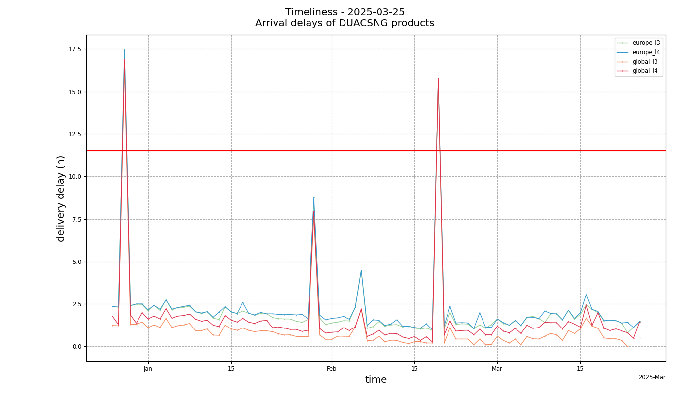 Timeliness of the DUACS NRT production for Copernicus Marine Service