Two types of sea level altimetric gridded products generated by the DUACS production system are currently available:
- Global and regional (European seas) gridded products generated and disseminated in the framework of the Copernicus Marine service (Details Copernicus Marine Service products).
- Global gridded product generated in the framework of the Copernicus Climate Change (C3S) service, and disseminated both via C3S and CMS. No regional product is available for C3S (Details in Copernicus Climate Service products).
Both Copernicus marine and climate (C3S) services aim at answering the users’ needs for two main kinds of applications:
- The retrieval of mesoscale signals in the context of ocean modeling and analysis of the ocean circulation at global or regional scale. This requires the most accurate sea level estimation at each time step with the best spatial sampling of the ocean. Such dataset is produced within the Copernicus Marine Service (CMS) (previously distributed by CNES/AVISO).
- The monitoring of the long-term evolution of the sea level for climate applications and the analysis of Ocean/Climate indicators (such as the global and regional Mean Sea Level evolution). This requires a homogeneous and stable sea level record. Such dataset is produced within the Copernicus Climate Service (C3S).
There are several differences in the way these two product lines are treated. These are summarized in the following table and detailed below.
Altimeter products |
Copernicus Marine Service |
C3S |
| Recommended use | Ocean modelling, ocean circulation and mesoscale signals | Long-term evolution, climate applications, ocean monitoring indicators |
| Constellation | All-satellite merged | Two-satellite merged |
| Reference field | Optimised reference field for repetitive missions | Mean Sea Surface |
| Processing | Delayed-time (near real time also available in the catalogue) | Delayed-time |
| Distribution | Copernicus Marine catalogue (previously distributed by CNES/AVISO) | C3S catalogue |
| Level 2 altimeter algorithms | Follow SL_cci recommendations when operationally compatible | |
| Temporal resolution | Daily optimal interpolation | |
| Spatial resolution | Gridded 1/8° (global) and 1/16° (regional products) | Gridded 1/4° (global) |
| Time span and timeliness | Jan. 1993 – about 5 months delay | |
| Temporal extension | 3 – 4 times per year | |
| Reprocessing | Every 3 – 4 years | |
| Origin | E.U. Copernicus | |
Table: Main characteristics of the Copernicus Marine Service and C3S DUACS altimeter sea level gridded products.
In the DUACS delayed-time products, the L2 altimeter standards compatible with the Copernicus operational constraints follow the ESA SL_cci recommendations.
The main differences between the Copernicus Marine Service and C3S altimeter sea level products are the following:
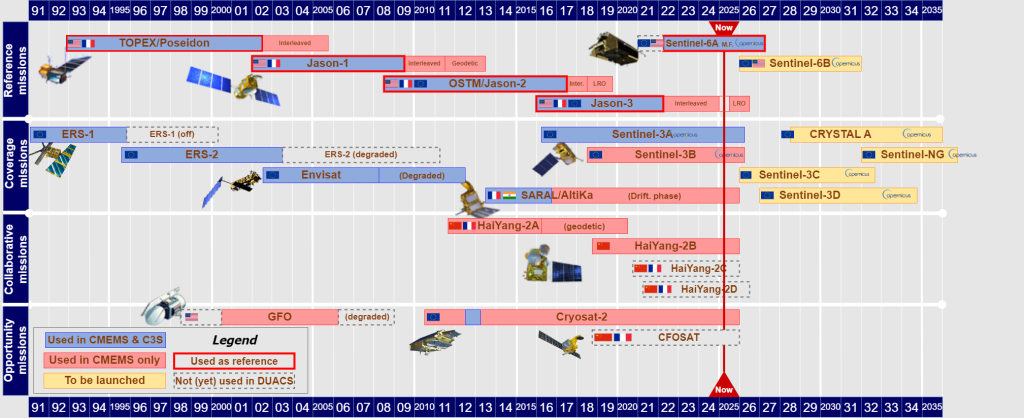
- The number of altimeters used in the satellite constellation: all available altimeters are included in the Copernicus Marine Service products whereas a consistent number (two) of altimeters are included in the C3S products. Previous studies (Pascual et al., 2006 and Dibarboure et al., 2011) underscored the necessity of a minimum of a two-satellite constellation for the retrieval of mesoscale signals. Within the production process, the long-term stability and large-scale changes are built upon with the records from the reference missions used in both Copernicus Marine Service and C3S products. The additional missions (e.g. up to 7 additional missions at the same moment in 2019) are homogenized with respect to the reference missions. However, the total number of satellites strongly varies during the altimetry era and some biases may appear with the introduction of a new satellite flying on a drifting orbit. This may affect the stability of the MSL at global and regional scales. Even if the spatial sampling is reduced with less satellites, the risk of introducing such an anomaly is thus reduced in the C3S products and the stability is improved. In the Copernicus Marine Service products, the stability is ensured by the reference missions and the mesoscale errors are reduced due to the improved ocean surface sampling thanks to the use of all satellites available in the constellation.
- The reference used to compute the sea level anomalies is a mean sea surface (MSS) for all missions in the C3S products whereas a mean profile of sea surface heights is used for missions with a repetitive orbit in the Copernicus Marine Service products. These mean profiles increase the local accuracy of the sea level estimates, but the combined use of both MSS and mean profiles for successive missions in the Copernicus Marine Service merged sea level record can be at the origin of some biases affecting the sea level stability. Even if this has a minor impact at global scale (with respect to the uncertainty on an interannual timescale), the stability of the regional MSL can be affected, particularly in the Mediterranean Sea and Black Sea (see QUID and PQAR). So,
the systematic use of the MSS for the sea level computation of all missions contributes to ensure the MSL stability in the C3S products,and the accuracy of the Copernicus Marine Service products is increased with the use of the mean profiles for repetitive missions. - The mapping process and the temporal and spatial scales used : with the DT-2024 version, the mapping process differ between the 2 products lines, with a multi-scale mapping used for the Copernicus Marine Service products and a simple scale mapping used for C3S pproduction (see Merged gridded (L4) products generation page). The spatial and temporal correlation scales have been adjusted in consistency with the different mapping technique.