Ocean Monitoring Indicators (OMIs) are quality checked and consistent information allowing regular monitoring of the ocean state, variability and change. Such OMIs are distributed by CNES/AVISO and also by the CMEMS (see DUACS products webpage).
Among the different indicators, the Global Mean Sea Level is a key indicator of climate change and can be computed from the DUACS products.
Computation
The stability of the altimeter GMSL is ensured by the TOPEX-Poseidon and the Jasons reference missions. The associated measurements are restricted to +/-66° latitude. The other complementary and opportunity missions contribute to improve the sampling of mesoscale processes, provide the high-latitude coverage and increase the product accuracy.
The AVISO (GMSL) is computed usig in upstream the calibrated and validated L2P along-track measurements from the reference missions only. The use of the Geophysical Data Records (GDRs) leads to a relatively short delay of 3 months compared with the present time. More information about the processing is available on AVISO+
The G/RMSL can also be computed from the L4 delayed-time (DT) multi-mission gridded DUACS sea level products distributed by CMEMS and C3S. The DT products are regularly reprocessed (~3-4 years) and the time series is regularly extended (about 3 times per year) with a timeliness of about 5 months due to the timeliness of the input data, the centered processing temporal window and the validation process. Details on the altimeter and processing algorithms are available in Pujol et al., 2016 and Taburet et al., 2018. The RMSL available on AVIO and Copernicus Marine Service are computed using in upstream to two-sat merged DUACS L4 series.
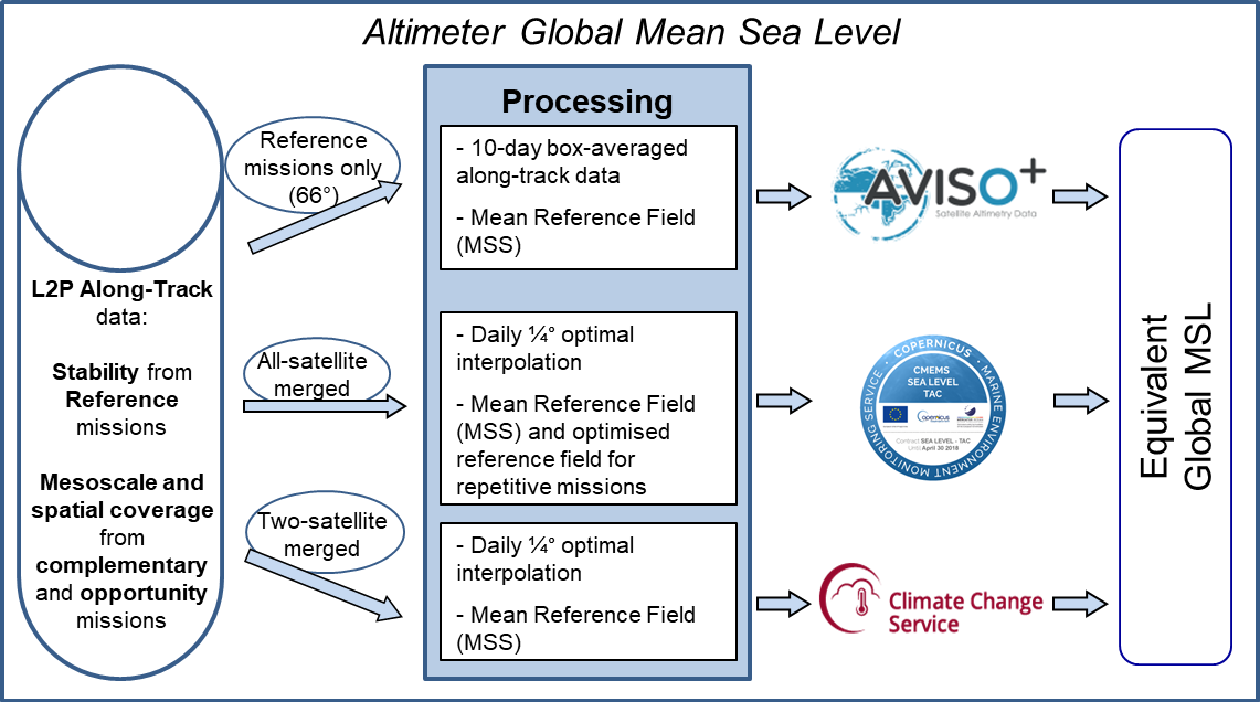
The AVISO ‘reference’ GMSL and the ones derived from the CMEMS and C3S gridded products (considering the same version and period) are considered to be identical since almost the same altimeter standards are used to compute the sea level anomalies and for all products, the long-term stability is ensured by the same reference missions. The remaining observed GMSL differences are not significant given the uncertainty considered on different scales (Ablain et al., 2015). Note that the situation is not the same on a regional scale where differences can be found according to the product used for the MSL computation.
Altimeter Global Mean Sea Level |
AVISO |
CMEMS |
C3S |
| Constellation | Reference missions only (66°) | All-satellite merged | Two-satellite merged |
| Reference field | Mean Sea Surface | Optimised reference field for repetitive missions | Mean Sea Surface |
| Temporal resolution | 10-day GMSL | Daily optimal interpolation | |
| Input data | GMSL derived from box-averaged (3°x1°) along-track data | GMSL derived from gridded 1/4° SLA maps | |
| Time span and timeliness | Jan. 1993 – 3 months delay (Geophysical Data Records) | Jan. 1993 – About 6 to 12 months delay | |
| Origin | CNES / AVISO | E.U. Copernicus | |
| Distribution | AVISO+ website | CMEMS catalogue (previously distributed by CNES/AVISO) | C3S catalogue |
Table: Main characteristics of the Global Mean Sea Level records derived from different altimeter products.
With the DUACS DT2021 version, using MGDR L2 upstream for Topex/Poseidon, a correction was introduced in the G/RMSL products to address the drift of the TOPEX‑A instrument observed between 1992 and 1998. With the Topoex/Poseidon GDR‑D reprocessing used for the DUACS DT‑2024 L3/L4 reprocessing, this drift correction has been modified and the previously estimated correction is no longer valid. A study is currently underway to re‑estimate the correction. The OMIs derived from these products are therefore not yet corrected for the TOPEX‑A drift. They will be updated as soon as the new correction is established.
Although the DUACS L3/L4 products are not corrected for Glacial Isostatic Adjustement (GIA), this correction is currently applied to the G/RMSL indicator derived from these products.