New Opportunities
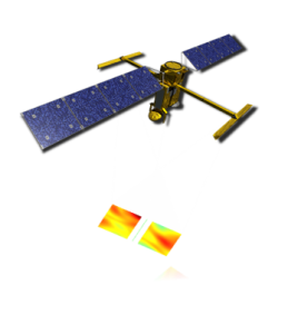
The Surface Water Ocean Topography (SWOT) mission was launched in December 2023. It is the result of cooperation between CNES, NASA and their partners from the Canadian and UK Space Agencies. SWOT carries a unique altimetric payload, including a Ku-band Jason-class nadir altimeter and a Ka-band SAR-interferometric (KaRIn) wide-swath altimeter providing 2 swaths 50-km wide. It offers new opportunity for the observation of the small mesoscale structures (e.g. Figure 1) over the oceans, including near coast and high latitude areas.
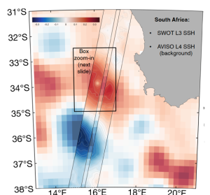
Figure 1: Illustration of the sea level anomalies L4 DUACS product deduced for multimission nadir measurements (background) and contemporaneous L3 SWOT-KarIN product. Courtesy M, Archer, JPL
The launch of the SWOT-KaRIn mission has opened up new opportunities for improving DUACS (Data Unification and Altimeter Combination System) high-resolution products. The integration of SWOT data promises to enhance the precision and capabilities of existing DUACS products, particularly for small mesoscale features.
Ongoing R&D Activities
Ongoing research and development (R&D) activities are focused on advancing DUACS processing methods to better leverage SWOT data for small mesoscale features in L3 and L4 products. This continued effort aims to optimize the accuracy and resolution of the products, making them more reliable for various applications in oceanography. The L3 and L4 KaRIn products are available on CNES/AVISO. This milestone represents a significant step forward in the development of high-resolution oceanographic products.
- First Demonstration of L3 Products: a Level-3 product was developed in the context of the SWOT Science Team Project DESMOS. It is the result of different processing steps (Figure 2) including the use of the state of the art of different geophysical corrections (e.g. Mean Sea Surface, ocean tide), aiming to improve the quality of the sea level measurement at small mesoscale; the multi-mission calibration, that makes the SWOT measurements consistent with other altimeters; the data selection, to identify invalid measurements; the sea surface height noise-mitigation, aiming reduce the noise level on SSHA and allowing the estimation of the geostrophic current and vorticity. L3 products are now capable of resolving small mesoscale structures, with a spatial resolution of approximately 20 km in diameter. Details are given in Dibarboure et al. (2024 and 2025). L3 KaRIn products are available on AVISO.
- First Demonstration of L4 Products : the first demonstration of L4 products incorporating SWOT-KaRIn data was also given. Combined with innovative mapping techniques (statistical model driven and data driven approaches), KarIn significantly reduces the errors of L4 mesoscale products and improves their resolution. These performances appear to be further enhanced by model-driven and data-driven mapping approaches. Details are given in Ballarotta et al, 2024. L3 KaRIn products are available on AVISO.
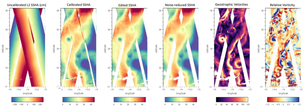
Figure: Illustration of the SWOT-KarIN L3 processing step
- Future Potential of KaRIn Data :
The SWOT-KaRIn data holds great potential to significantly enhance DUACS products, particularly in polar and coastal regions. As processing methods continue to improve, these regions are expected to benefit from higher-resolution data, offering more detailed insights into oceanographic features.