Full reprocessing of the DT products: DUACS DT-2024
In November 2024, a new version of the DUACS delayed time (MY/DT) products was delivered. This “DT-2024” version replaces the “DT-2021” available since December 2021. At the same time, the near real time (NRT) DUACS products also evolved to be consistent with the new version of the DT-2024 products. The different evolutions are implemented in the DT-2024 version, both for Level-3 (L3) and Level-4 (L4) products. They are summarized in the Table 23 and detailed below.
Table : Overview of the changes introduced with DT-2024 REP product version.
| Evolution description | Description of the impact |
| L3 (and resulting L4): Use new altimeter standards and geophysical corrections (e.g., ocean tide, DAC, …) | Improved accuracy of SLA content; Regional biases; regional MSL trend impacted |
| L3 (and resulting L4): Use new Mean Sea Surface (non-repetitive missions and recent missions) or Mean Profile (repetitive missions) | Improved accuracy of SLA content; Regional biases |
| L3 & L4: Use new MDT | Improved geostrophic current; regional biases |
| L3: Use new methodology for LWE correction computation | Improved LWE correction |
| L4: Use new methodology for mapping and geostrophic current computation | Improved mesoscale signal on L4 products |
| L4: Grid spatial resolution change | Finner spatial grid available |
| L3 & L4: Copernicus Marine Service catalogue changes | Change in products/datasets names |
New altimeter standards and geophysical corrections
In the frame of the SALP[1] (Service d’Altimétrie et de Localisation Précise) project supported by CNES (Centre National d’Etudes Spatiales) and of the Sentinel Marine Altimetry L2P-L3 Service (in cooperation agreement with EUMETSAT within the Copernicus Program[2] funded by the European Union), the measurements from the different altimeter missions available since 1993 have been reprocessed taking into account the up-to-date and homogeneous altimeter standards and corrections. Regional biases also have been estimated for the reference mission series (Topex/Poseidon, Jason-1, Jason-2, Jason-3, Sentinel-6A) in order to ensure the continuity of the sea level trend at regional scale.
These changes are detailed in (Kocha et al., 2023) and summarized in Table 14. They contribute to improving the quality of the L3 and resulting L4 products. Compared to previous versions (e.g. DT-2021) mesoscale improvements have been made by means of:
- Instrumental corrections (thanks to the reprocessing of Topex, Jason 3, Sentinel 3A/B and 6).
- Geophysical corrections, with impact mostly at high latitudes and along the coast with the newcorrections :
- Ocean tide correction: FES 2022 (Carrere et al., 2023) which explain 70% of improvements brought by the DT-2024. The use of the FES_2022 model instead of FES_2014 model leads to a strong reduction of the SLA variance in the coastal band (< 100 km). This reduction reaches -20 cm² (Jason-3) to -50 cm² (AltiKA & Cryosat-2) at few kilometers near the coast.
- Dynamic atmospheric correction: TUGO
[1] https://www.aviso.altimetry.fr/en/home.html
[2] https://marine.copernicus.eu/
New Mean Sea Surface and Mean Profiles
The New MSS Hybride_2023, presented by (Laloue et al., 2024) is used in the DUACS DT-2024 product version, specifically in NRT for all missions; in MY for missions with non-repetitive orbit and new orbit missions. The MSS Hybrid_2023 combines the MSS CNES_CLS_2022, SCRIPPS_2022 and DTU21, taking advantage of their respective features. It contributes to improve the signal at small mesoscale (“at small scale between 15km and 100km , especially near the coast and in high MS gradient areas.
For MY repetitive missions, specific mean profiles, estimated along the repetitive tracks are used as detailed in MY DT-2024 altimeter standards.
New MDT
The MDT used in the MY DUACS reprocessing is described in section MY DT-2024 altimeter standards.
Improved MDTs are used in the DT-2024 product version as follows:
- For the global ocean : use of a new MDT CNES_CLS_2022 (Jousset et al., 2023), combined with CMEMS_2020 regional MDTs for Mediterranean and Black Sea (Jousset and Mulet, 2020). This hybrid MDT is available on AVISO or in the Copernicus marine Service catalogue (product 008_063[1])
- For Europe: use of the new regional Europe CMEMS_2024 MDT. This hybrid MDT is available in the Copernicus marine Service catalogue since November 2024 (product 008_070[1])
The main improvement of the new CNES-CLS22 MDT over the previous CNES-CLS18 MDT is in the Arctic, with better coverage, no artifacts and a more realistic solution. Global improvement of the CNES-CLS22 MDT is also remarkable, with drifter independent measurements (up to 10% of error reduction). Nevertheless, few areas appear to be degraded: south of Greenland, in the far north of the Pacific Ocean (in the Gulf of Alaska, and close to Russia) and in the southern Pacific.
Compared to the global CNES_CLS-2022 MDT, the Europe CMEMS_2024 version uses measurements from the high frequency radar in the Bay of Biscay and benefits from additional drifter measurements (year 2022), corrected with an improved estimation of the Ekman current component. (Colling, 2001) It results in a higher resolution and better accuracy of this MDT in the Atlantic region compared to the global version.
The quality of the MDT fields used in the DUACS processing is fully described in MDT specific QUID document.
[1] Global Ocean Mean Dynamic Topography | Copernicus Marine Service
New mapping methodology (LWE and SLA)
The methods used to process L4 gridded products from the merging of L3 along-track products have evolved from the Optimal Interpolation (OI) method, as detailed by Le Traon et al (1998). and Pujol et al., (2016) to the Multi-Scale Inversion of Ocean Surface Topography (MIOST) approach. While the MIOST system can also be considered a form of optimal interpolation, it’s important to note that OI maps are constrained by a single-scale covariance function Arhan and De Verdiére, (1985); Le Traon et al.,( 1998a) and primarily focus on geostrophic circulation (processes with typical space and timescales greater than 100 km and 10 days). The multiscale approach of the MIOST method allows for the resolution of some of the surface variabilities missing in OI, by incorporating covariances of various surface processes within a single inversion. In MIOST, the covariance functions are represented as wavelet modes, and inversion is performed using a variational approach (Ubelmann et al., 2021). In the new reprocessing, our focus was solely on the geostrophic component and long wavelength error component, as explored in (Ubelmann et al., 2021) and (Ballarotta et al., 2023). These studies have compared the performance of the MIOST system with the current DUACS mapping system, demonstrating that while MIOST is globally comparable to OI, it shows regional improvements, particularly in mid-latitudes, where complex turbulent systems, such as the Gulf Stream and Kuroshio current, are better mapped by MIOST than OI.
The quality of the new SLA product has been evaluated through comparisons with an independent dataset. This analysis specifically targets improvements in mapping between the MIOST and OI products by using an independent along-track dataset for performance assessment. We generated maps excluding the Saral/AltiKa altimeter to enable independent evaluation. The SSH gridded data were interpolated to the locations of the independent along-track SSH measurements. The difference between gridded SSH and along-track SSH was computed, and a statistical analysis of this SSH error was performed within 1° × 1° longitude × latitude grid cells. Before this analysis, a filtering operation was applied to isolate the spatial scales of interest, such as the 65–500 km range, which typically represents the medium mesoscale ocean signal. This filter removes noise from the reference signal (along-track) and possible large-scale biases (scales >500 km).
The following figure illustrates the mapping error differences between MIOST and OI for all spatial scales and, specifically, for the 65 to 500 km range. The colour scale bar indicates the reduction/increase in the mapping error with MIOST compared to OI. Overall, MIOST demonstrates smaller mapping errors than OI across all spatial scales, particularly at mid-latitudes, with an average reduction of 5%. The most significant reduction in mapping error is observed in high-variability regions. However, in intertropical and coastal regions, the MIOST product shows degradation compared to the OI product. For the 65 to 500 km range, MIOST mapping errors are reduced by approximately 8% compared to OI in high-variability mid-latitude regions. In low-variability regions, the mapping error is about 1% smaller with MIOST, although local areas such as the Argentine Sea, the Siberian plateau, and the New Zealand plateau, may exhibit larger errors with MIOST. The following table provides a summary of the comparison results across different regions (Global, coastal, equatorial band, low-variability, and high-variability). Overall, MIOST SSH maps align more closely with the independent SARAL/AltiKa observations than OI maps.
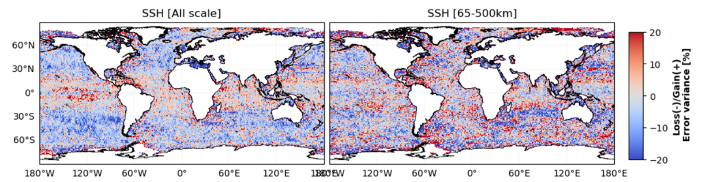
Table :Variance of the differences between gridded (L4) DT2021 all-sat-merged products from MIOST (one altimeter was kept independent for validation) and independent SARAL-DP/AltiKa (ALG) along-track measurements over 2018 for different geographic selections. Units: cm². In parenthesis: variance reduction (in %) compared with the results obtained with the DT2021 products from DUACS. Statistics are presented for all wavelenghs (left column) and wavelengths ranging between 65-500 km (right column).
|
Mapping_err_var [cm²] |
Mapping_err_filtered_var [cm²] | |
| global
(lat between 60° and -60°) |
15.49 (-2.82%) | 3.39(-2.20%) |
| Coastal | 25.29(1.08%) | 5.25(-0.56%) |
| Offshore_highvar | 30.43(-3.25%) | 10.27(-7.64%) |
| Offshore_lowvar | 12.21(-3.25%) | 2.26(-1.31%) |
| Equatorial_band | 13.70(2.01%) | 2.91(0%) |
The Long-Wavelength Error (LWE) correction delivered in L3 product is computed as the final step of multi-mission cross-calibration processing. It is expected to remove local SLA residual biases between neighbouring altimeter tracks: biases induced by imprecision of the different correction applied (e.g., residual ocean tide, residual DAC, residual wet-troposphere, residual ionosphere signal, etc.).
The methodology used in DUACS DT-2021 product version follows the method described by (Traon and Dibarboure, 1999). The LWE correction was estimated with higher frequency along the different tracks (100 km), and by using an Optimal Interpolation methodology to retrieve the correction on each along-track position.
The methodology employed in the MIOST product is based on the approach outlined by (Ubelmann et al., 2021). In this method, the Long-Wavelength Error (LWE) correction is estimated through the simultaneous inversion of mesoscale variability and LWE signatures in sea surface height measurements. This inversion is conducted on a reduced-order basis, with separate decompositions for mesoscale and LWE components of the topography, and is practically implemented using a conjugate gradient method.
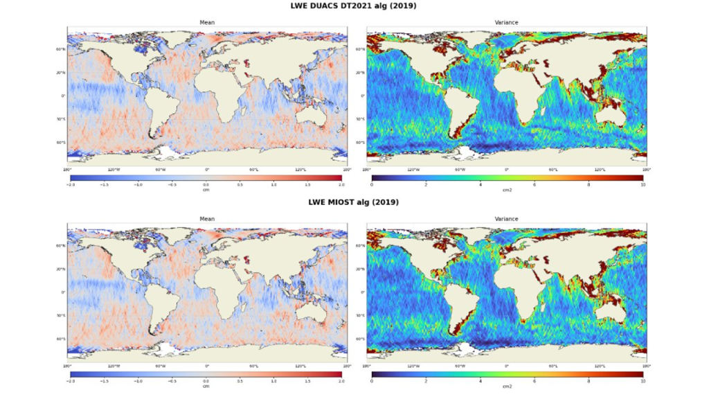
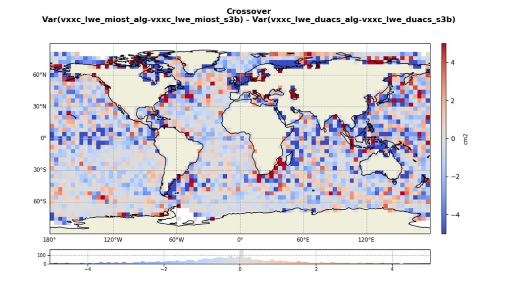
The spatial pattern of the LWE solution (mean, variance) shows relative similarity between the MIOST and DUACS solutions (Figure 2). The analysis of the variance of the SLA differences at multi-mission cross-over positions (Figure 3) shows that the DT-2024 LWE computation methodology improves the consistency between the different missions, particularly along the European coast and in the Pacific and Indian Oceans.
New geostrophic current computation methodology
The geostrophic current computation methodology has been slightly revised since the previous DUACS -DT2021 reprocessing.
The anomaly of the geostrophic current disseminated to users is derived from gridded SLA field. In the DUACS-DT2021, it is computed with the derived variable generation method described in subsection II.4.7.3
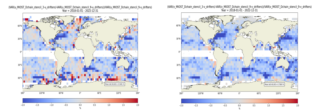
In the new DUACS-DT2024 products, geostrophic currents are calculated from the gridded SLA field using a finite-difference method (a 3-point stencil width) for latitudes beyond the ±5°N range. Within the equatorial band, the methodology remains unchanged and continues to follow the Lagerloef approach.
These evolutions in the geostrophic current computation were motivated by the fact that the refinement of the L4 spatial grid resolution was done in the new reprocessing (from ¼° grid spacing to 1/8° for global product; from 1/8° to 1/16° for regional products). Additionally, a comparison of the gridded geostrophic currents with independent drifter measurements revealed a slight improvement in consistency when using the finite difference approach compared to the 9-point stencil differentiation method (Figure 4).
L4 grid spatial resolution change
The new products are provided on a finer spatial grid compared to the previous reprocessing. The new global products have a spatial resolution of 1/8°, while the regional products offer even finer spatial sampling at 1/16°. The temporal sampling remains unchanged, with data available on a daily basis.
Copernicus Marine Service Catalogue change
The new MY DT-2024 L3 series are accessible through the same datasets than previously available (except new datasets created for new altimeter missions). Nevertheless, the NetCDF files already available for the current DT-2021 series have been removed and replaced by new files containing the new DT-2024 series. Additionally, obsolete datasets have been removed.
The new MY DT-2024 L4 “all-sat-merged” series are accessible through new datasets reflecting the change in grid spatial sampling. Part of previous datasets have been removed. Details are given in the following Table:
Table: Updated DT-2024 of GLObal and EURopean Sea MY L4 Product classification: Product and Dataset Identifications
| Product | Datasets for DT-2021 series (will be removed after DT-2024 release) | Datasets for DT-2024 series |
| SEALEVEL_EUR_PHY_L4_MY_008_068 | cmems_obs-sl_eur_phy-ssh_my_allsat-l4-duacs-0.125deg_P1D
cmems_obs-sl_eur_phy-ssh_myint_allsat-l4-duacs-0.125deg_P1D |
cmems_obs-sl_eur_phy-ssh_my_allsat-l4-duacs-0.0625deg_P1D
cmems_obs-sl_eur_phy-ssh_my_allsat-l4-duacs-0.0625deg_P1M-m |
| SEALEVEL_GLO_PHY_L4_MY_008_047 | cmems_obs-sl_glo_phy-ssh_my_allsat-l4-duacs-0.25deg_P1D
cmems_obs-sl_glo_phy-ssh_my_allsat-l4-duacs-0.25deg_P1M-m cmems_obs-sl_glo_phy-ssh_myint_allsat-l4-duacs-0.25deg_P1D cmems_obs-sl_glo_phy-ssh_myint_allsat-l4-duacs-0.25deg_P1M-m |
cmems_obs-sl_glo_phy-ssh_my_allsat-l4-duacs-0.125deg_P1D
cmems_obs-sl_glo_phy-ssh_my_allsat-l4-duacs-0.125deg_P1M-m |
The new MY DT-2024 L4 “Climate” (two-sat-merged; C3S) series are accessible through the same datasets than currently available. Nevertheless, the NetCDF files already available for the previous DT-2021 series have been removed and replaced by files containing the DT-2024 series. Additionally, obsolete datasets have been removed.