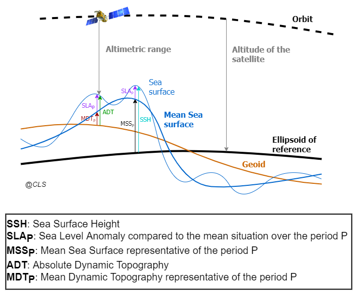
The altimeter measures the ‘Altimeter Range’ which is the distance between the centre of mass of the satellite to the surface of the Earth (see Figure 1). This allows computing the ‘Sea Surface Height’ (SSH) which is the sea surface height above the reference ellipsoid. The ‘Satellite Altitude’ refers to the distance of the centre of mass of the satellite above a reference point. The reference point will usually be either on the reference ellipsoid or on the centre of the Earth.
SSH = Satellite Altitude – Altimeter Range – Corrections Equation 1
The ‘Corrections’ due to environmental conditions need to be applied in order to retrieve the correct ‘Sea Surface Height’ (Eq. 1). They are listed in the … page for NRT), and in the … page for DT.
The Mean Sea Surface (MSSP) is the temporal mean of the SSH over a period P (Eq. 2). It is a mean surface above the reference ellipsoid and it includes the Geoid.
MSSP=<SSH>P Equation 2
Note that the MSS used in DUACS products (he … page for NRT), and in the … page for DT) is not distributed by CMEMS but is available via the Aviso+ website (after registration):
The Sea Level Anomaly (SLAP) is the anomaly of the signal around the mean component. It is deduced from the SSH and MSSP. A MSS can be used to compute the SLA, i.e. the height between the mean state of the SSH (over a specific period N, see the altimeter reference period page) and the instantaneous sea surface:
SLAP = SSH – MSSP Equation 3
The Mean Dynamic Topography (MDTP) is the temporal mean of the SSH above the Geoid over a period P.
MDTP = MSSP – Geoid Equation 4
The Absolute Dynamic Topography (ADT) is the instantaneous height above the Geoid. The geoid is a gravity equipotential surface that would correspond with the ocean surface if ocean was at rest (i.e., with no currents under only the gravity field). Then, when the ocean is also influenced by wind, differential heating and precipitation and other sources of energy, the ocean surface moves from the geoid. Thus, the departure from the geoid provides information on the ocean dynamics.
The ADT is the sum of the SLAP and MDTP:
ADT= SLAP + MDTP = SSH – MSSP + MDTP Equation 5
The reference period P considered can be changed as described in Pujol et al. (2016).