Polars areas
Objective
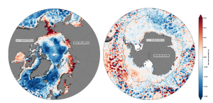
The main objectif of this goal is to provide an estimate of sea surface height over ice-covered areas

Figure: Illustration of the sea level anomalies L4 product in polar areas
Achievements and Challenges
Enabled by:
- Enhanced DUACS processing methods to handle altimetric data in ice fracture zones (Veillard et al., 2024).
- Specific upstream inputs tailored to the specular echoes available in fracture zones.
Major Challenge: Ensuring the continuity of polar products with those from the open ocean.
Current Status: Experimental/demonstrative products have been available on AVISO+ since 2021.
L3 5Hz and coastal
Objective
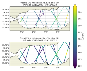
This resolution makes it possible to better resolve small mesoscale features (up to ~40 km) and coastal zones.

Figure: Illustration of the sea level anomalies L3 1Hz (top) and 5Hz (bottom) products in the Alboran sea
Achievements and Progress
Enabled by:
-
- L3 products sampled at 5Hz (~1 km), based on 20Hz upstream data with specific retracking or corrections that significantly reduce noise levels (Pujol et al., 2023).
Availability: Products have been included in the Copernicus Marine Service catalog since November 2022.
Ongoing R&D: Efforts to improve altimeter processing specifically for coastal areas.
L4P product
Objective
- Dérivé des produits L4 DUACS pour soutenir les analyses et applications océaniques avancées.
Key Features
- Oceanic Indicators: Provide critical insights for monitoring the state of the ocean (Bessière et al., 2013).
- Lyapunov Exponents: Help detect the position of fronts and filaments, aiding in understanding ocean dynamics (d’Ovidio et al., 2004).
- Eddies Atlas: Tracks the characteristics of mesoscale eddies from their formation to dissipation, supporting mesoscale research (Pegliasco et al., 2022).

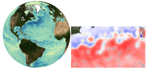
Figure: Illustration of DUACS EKE (left) and mesoscale eddies detection (right)